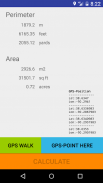


GPS area measure - land survey

Mô tả của GPS area measure - land survey
Want to know the true size of your land?
Measure the perimeter of a field?
Determine the exact position of that border stone?
Collect GPX-data and visualize at home?
How to use:
Simply press the green button "GPS WALK" and start walking.
Now walk along the border of the area.
If there is any obstruction just press "PAUSE" and move on to the next accessible point.
Continue with "GPS WALK" or "GPS POINT HERE".
Once you are done click "CALCULATE" and the app will determine the area and perimeter.
The last position will automatically connect with the first position so you do not need to worry about closing the area exactly.
For convenience, area and perimeter are presented in imperial and metric units,
"m2", "acre", "squarefeet" for areas and "m", "feet" and "yards" for perimeters.
Now you can send the GPS-data via email to your (or other peoples) mail-account.
Cut the GPX-part and paste it into one of the many GPS-visualizers available on the Internet.
How it works:
The app strictly follows the WGS84-model to transfer Latitude- and Longitude-data to metric distances between waypoints.
WGS84 is currently the reference system being used by the Global Positioning System.
It originally used the GRS 80 reference ellipsoid, but has undergone some minor refinements in later editions since
its initial publication. WGS 84 uses the EGM96 (Earth Gravitational Model 1996) geoid, revised in 2004.
This geoid defines the nominal sea level surface by means of a spherical harmonics series of
degree 360 (which provides about 100 km latitudinal resolution near the Equator).
Permissions needed:
android.permission.ACCESS_FINE_LOCATION
android.permission.ACCESS_COARSE_LOCATION
android.permission.ACCESS_LOCATION_EXTRA_COMMANDS
android.permission.LOCATION_HARDWARE
this app will:
- measure acreage
- convert acres to square feet (internal)
- assists in land survey
- measure the total distance of your waypoints
- calculate perimeter
- area measurement
- fields area measure
- gps walk
Muốn biết kích thước thực sự của đất của bạn?
Đo chu vi của một trường?
Xác định vị trí chính xác của mà đá biên giới?
Thu thập GPX-dữ liệu và hình dung ở nhà?
Làm thế nào để sử dụng:
Đơn giản chỉ cần nhấn vào nút màu xanh lá cây "GPS WALK" và bắt đầu đi bộ.
Bây giờ đi bộ dọc theo biên giới của khu vực.
Nếu có trở ngại bất kỳ chỉ cần nhấn "PAUSE" và chuyển sang các điểm truy cập tiếp theo.
Tiếp tục với "GPS WALK" hoặc "GPS POINT HERE".
Một khi bạn đã làm xong bấm vào nút "tính toán" và ứng dụng sẽ xác định diện tích và chu vi.
Vị trí cuối cùng sẽ tự động kết nối với vị trí đầu tiên, do đó bạn không cần phải lo lắng về việc đóng cửa khu vực này một cách chính xác.
Để thuận tiện, diện tích và chu vi được thể hiện trong đơn vị hoàng đế và số liệu,
"M2", "mẫu", "squarefeet" cho các khu vực và "m", "chân" và "bãi" cho chu vi.
Bây giờ bạn có thể gửi dữ liệu GPS qua email đến email tài khoản của bạn (hoặc người khác).
Cắt GPX-phần và dán nó vào một trong nhiều GPS-visualizers có sẵn trên Internet.
Làm thế nào nó hoạt động:
Ứng dụng tuân thủ nghiêm ngặt các WGS84-mô hình để chuyển Latitude- và Longitude dữ liệu để khoảng cách giữa số liệu waypoints.
WGS84 hiện là hệ quy chiếu được sử dụng bởi hệ thống định vị toàn cầu.
Nó ban đầu được sử dụng tài liệu tham khảo ellipsoid GRS 80, nhưng đã trải qua một số cải tiến nhỏ trong các phiên bản sau này kể từ
công bố ban đầu của nó. WGS 84 sử dụng (Trái đất Hấp dẫn mẫu 1996) geoid EGM96, sửa đổi năm 2004.
geoid này định nghĩa bề mặt mực nước biển không đáng kể bằng phương tiện của một loạt các giai điệu âm hình cầu của
360 độ (cung cấp độ phân giải vĩ độ khoảng 100 km gần đường xích đạo).
Quyền cần thiết:
android.permission.ACCESS_FINE_LOCATION
android.permission.ACCESS_COARSE_LOCATION
android.permission.ACCESS_LOCATION_EXTRA_COMMANDS
android.permission.LOCATION_HARDWARE
ứng dụng này sẽ:
- Biện pháp diện tích
- chuyển đổi mẫu để feet vuông (nội bộ)
- hỗ trợ trong cuộc khảo sát đất
- đo lường tổng khoảng cách waypoints của bạn
- tính toán chu vi
- đo lường khu vực
- các lĩnh vực đo lường khu vực
- gps đi bộ


